| Home | Racing | Training | Rollerskiing | Trails | Weather | Equipment | Forums | Photos & Video |
|
|||||
|
|||||
|
Equipment [Greg is one of the regulars on the Saturday morning rollerski sessions at Kensington Metropark. He always has the cool toys... - Mike] After watching Lance power his way up the steepest climb in this year's Tour de France, I felt like finding a mountain to climb. Living here in southeastern Michigan, I didn't expect to find one. But with the help of my Dick Tracy wonder, the Polar S710 with built-in altimeter, I could at least know what I did find. Considered the toughest climb in the 2002 Tour de France, Mont Ventoux rises 5280 feet in 21km at an average grade of 7.6 percent. Lance made the fastest climb to the summit in Tour history. He climbed it in 58 minutes. So how do the local grades compare? I set out on my bike to find out.
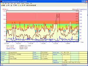
The Polar S710 heart monitor was set to record my heart rate, bike speed and altitude. The attached graph shows the whole ride. The red line on top is my heart rate. The middle brown line is altitude and the blue line on the bottom is the bike speed. The minimum elevation shown is 175 feet above sea level. Think of that as zero. Since I never set a reference point, only the relative altitudes are meaningful. Starting my bike ride at the East Boat Launch parking lot in Kensington, I took off north down the park road, encircling the park counterclockwise. There are two significant hills on the main road in Kensington. The first tops out at the park office and the second peaks at the toboggan hill entrance. These hills show up as nearly identical on the graph between 10 and 15 minutes into the ride. The software that produces the graph allows you to zoom in and will compute the grade and elevation change for any small section. Both of these hills show an 80-foot ascent and 5.4% and 5.7% average grade. Mere molehills compared to Ventoux. I continued my bike ride out of the park and south onto Kensington road and then into Island Lake State Park. The road inside the park is freshly paved and lightly traveled which makes for a great bike ride. There are a few short steep hills that allow quick intervals, but as the graph shows, there are no big hills in Island Lake State Park. At about the 1.5 hour mark, I was out of the park and back onto Kensington road heading north to where the toughest climb I know of in the area looms about 2 miles north of I-96. The top of this climb bristles with radio towers and the view to the west and south is fantastic. The interference from the radio towers played havoc with my heart monitor, causing it to freeze at 108. I get frustrated when this happens. I feel like I am not getting "credit" for my efforts. But while my heart rate hit a plateau, the hill kept going up. A sign at the top of the hill, facing the traffic going down hill, like they need to know, says 8% grade. That may be optimistic. The Polar software shows a 200-foot ascent over 1.3 miles for a 2.8% average grade. But of that 200 foot ascent, 140 feet of it occurs over just .4 miles for a grade of 6.6%. That gets us close to the 8% number, and perhaps for some short section, 8% is accurate. Mont Ventoux averages 7.6% and has sections as steep as 15%. I was not racing, but it took me 2:25 to climb the 140-foot section. Multiply that by 37 to get the same 1-mile elevation change as on Ventoux and I would be up in 89 minutes. Half an hour behind Lance, but not too bad if I could actually maintain that pace for 89 minutes. Of course we could also take my 100-yard dash time, multiply it by the appropriate number and maybe it would show that I could run a sub 4-minute mile. If only I could maintain the pace. Sure I could. It would take 26 trips up the full 200 foot Kensington road hill to equal the elevation change on Mont Ventoux, but it would not be as steep, and of course you would get to rest as you zoomed down at 40 miles per hour between climbs. It took me over 5 minutes to get up the full hill. Figuring 2 minutes to get back down, we are talking something like 3 hours total. Sounds like a nice little interval workout. Perhaps we could find room for this in the two-day fall camp. You will notice a second peak shortly after the first. That is the same hill coming back the other way. After struggling up the hill, I rode down the backside a few hundred yards, caught my breath, then turned and rode back down. That is why the graph shows a double peak. Slightly higher the second time over due to the margin of error in the altimeter. The last big hill for the day is the scenic viewpoint road inside Kensington Park. While this hill is about the same size as the first two I talked about, it makes for an easier return because you only have the one hill to climb. For us skiers, hill climbing on a bike may be the best way to use a bike to prepare for skiing. It is obvious that even the biggest hills here in southeastern Michigan are small compared to any real mountains. It would be possible though, to devise a route of about 15 miles that incorporates all the major hills near Kensington Park. Repeated 2 to 4 times would give a great workout. Probably not the workout that Lance uses to get ready for Ventoux, but then he probably could run a sub 4 minute mile if he put his mind to it. |